The Brazilian National Library cartographic heritage is composed by more than 22 thousand maps, among manuscripts and printed matters, and approximately 2,500 atlases, beyond a diversity of monographs and treaties about the theme.
The collection encompasses pieces of significant artistic and historical value, not only from Brazil, but also from the Portuguese overseas empire and other parts of the world. The cartographic set - which includes maps and atlases - is of special value because it allows the study of the cartographic technique, as well as of its changes and evolution throughout the centuries.
The most notable, for example is Sebastian Münster's planisphere, from 1552, to which the work "Cosmographia universals" belongs, and the successive editions of Claude Ptolomeu's Geography, with woodcut maps, engraved in metal and watercolored. The oldest, from 1486, covers the known world in the 15th century (Europe, Africa and Asia) and describes the Indian Ocean as an enclosed sea, based on the ptolomaica theory that in the south of the African continent the oceans did not establish any linking. Although the Geography of 1486 is a reissue of 1482, published in Ulm, it is distinguished by two additional texts Registrum Alphabeticum (alphabetical Register) and De locis ac mirabilus mundi (an anonymous treaty about the wonders of the world).
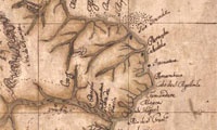
The heritage still has “atlases and wall maps of Miguel Antonio Ciera ", an Italian astronomer hired by the Portuguese crown to participate in the surveys of the borders in the South Region of Brazil in order to establish the landmarks of Madrid Treaty from 1750. Despite its vast cartographic production, only these two cartographic drawings are known, which had been nominated in UNESCO's National Registry of the World Memory Program (MowBrasil) and in the Registry of the World Memory Program in Latin America and the Caribbean (MowLac), in 2012